
Monday, June 9, 2008
 Source:

Part of Mekong River
Source: http://kekexili.typepad.com/life_on_the_tibetan_plate/images/2007/11/14/mekong_river_in_dzado.jpg

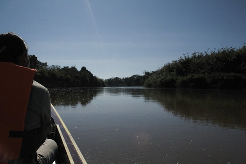
 A boat tour along Mekong River
Sunday, June 8, 2008

Qinghai Province (Zaqu is located at the south of Qinghai)

A view of Mekong River at at Luang Prabang , a city located in north central Laos
Source: http://en.wikipedia.org/wiki/Mekong_River and http://en.wikipedia.org/wiki/Luang_Prabang

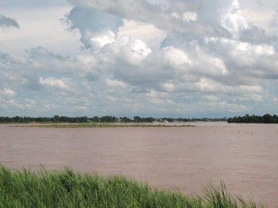
A view of Southern Laos from the Mekong River
Source: http://en.wikipedia.org/wiki/Mekong_River

A tourist travelling along the Ruak River
Source: http://farm3.static.flickr.com/2173/2130030692_cd9a65bf78.jpg

A view of the Golden Triangle
Source: http://en.wikipedia.org/wiki/Mekong_River
The river then divides Laos and Thailand, before a stretch passing through Laos alone. It is known as Maè Nam Khong (Mother of all rivers) in both Lao and Thai. The river again marks the Lao-Thai border in the stretch which passes Vientiane, followed by a short stretch through Laos alone.
A view of Mekong River in Vientiane
Source: http://i.pbase.com/u35/andrewd/upload/23391803.IMG_1552.jpg
In Cambodia, the river is called the Mékôngk or Tonle Thom (great river). Just above Phnom Penh is the confluence with the Tonle Sap, the main Cambodian tributary. Below Phnom Penh, it divides into the Bassac and the Mekong proper, which both flow into the Mekong Delta in Vietnam.

A view of Mekong River from Phnom Penh
Source: http://andybrouwer.co.uk/200311.jpg
In Vietnamese, the river as a whole is known as Mê Kông. The part flowing through Vietnam, known as Sông Cửu Long (river of nine dragons), divides into two major branches, the Tiền Giang (Front River) and Hậu Giang (Back River). These in turn enter the sea through nine estuaries, thus the Vietnamese name. Here are the pictures for the tributaries and distributaries of the Mekong River.
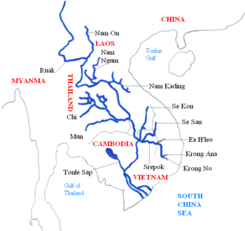
A detailed picture of the tributaries of Mekong River

There are 5 distributaries for Mekong River: Bassac River, My Tho River, Ham Luong River, Co Chien River and Ba Lai rivers. The above picture is the Bassac River.
Source: http://en.wikipedia.org/wiki/Bassac_River
Saturday, June 7, 2008

Map of Mekong River in 1715

The members of the French Mekong Expedition of 1866


2nd Thai-Lao Friendship Bridge: It connects Mukdahan to Savannakhet. The two-lane, 12-metre-wide, 1600-metre-long bridge opened to the general public on January 9, 2007.

3rd bridge: Pakxe Bridge
Source: http://en.wikipedia.org/wiki/Pakxe
Dams:
There are a total of 8 dams built across parts of Mekong River in Western China, namely (from the oldest to the latest) Ganlanba Dam, Mengsong Dam, Manwan Dam, Dachaoshan Dam, Gongguoqiao Dam, Jinghong Dam, Xiaowan Dam and Nuozhadu Dam.

There are many type of fishes, reptiles and mammals in Mekong River and the following are some of the unique fishes, reptiles and mammals.

Source: http://www.flmnh.ufl.edu/natsci/nimages/crocplan/054.jpg


Giant Mekong Catfish, Endangered
 Irrawaddy dolphin, Rare


Smooth-coated otter, vulnerable
Source: http://www.tribuneindia.com/2006/20060601/cth6.jpg
Myth:
Balls of light are observable from time to time rising from the water's surface in the stretch of the river near Vientiane or Nong Khai. These are sometimes referred to as Naga fireballs. The locals attribute the phenomenon to Phaya Naga, Mekong Dragons.

Naga fireball (in purple circle)
Source: http://www.moohin.com/trips/nakhonphanom/payanak/150/big.jpg

Close up picture of Naga fireball
Friday, June 6, 2008


In the background are rubber plantations and shifting cultivation
Source: www.natureproducts.net/Ecotourism/Mekong.html
Poverty stricken Cambodia is an example of one nation that is completely dependent on the river for food and the vast majority of its fledgling economy.

Dai ladies gleaning the shallow waters of the Mekong for shells
Source: http://natureproducts.net/Ecotourism/Dai_gleaning400.jpg
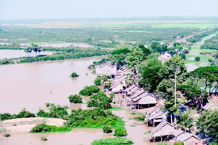
The annual floods provide much needed water for crops of the otherwise dry dusty land, and to refresh Tonle Sap, a combined lake and river system of huge importance to Cambodia.
 A satellite image of Tonle Sap
Source: http://en.wikipedia.org/wiki/Tonle_Sap

Flooding at a village near Tonle Sap
Source: http://www.scienceclarified.com/landforms/images/ueol_02_img0058.jpg
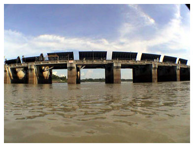
Dams have been built across Mekong River to use its water to generate hydroelectricity.

Pak Mun dam at Thailand
Source: http://www.prachatai.com/english/upload/pictitle/20070619132619_18_065256_47.jpg
Thursday, June 5, 2008


Dragon's Teeth Rapid on The Mekong River

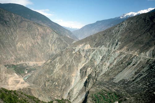
Lancang gorge in Tibet

Mekong River valley near Tibet
Source: http://www.arizonahandbook.com/images/C20-34.jpg
There is a famous waterfall, Khone Falls near the Cambodian border. The Khone Falls are the main reason that the Mekong is not navigable into China.

Source: http://upload.wikimedia.org/wikipedia/commons/thumb/0/0c/Somphamit.jpg/800px-Somphamit.jpg

A bigger view of the Khone Fall
Source: http://www.cpamedia.com/travel/laos_champasak_to_bolaven_plateau/khone_phapeng_falls_243x164.jpg
The Mekong Delta is the region in southwestern Vietnam where the Mekong River approaches and empties into the sea through a network of distributaries.
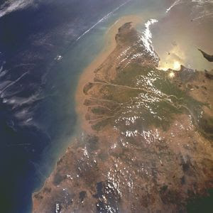

A clear view of Mekong Delta and the distributaries (with the name written in bold red)
Source: http://alliance.la.asu.edu/mywonderfulworld/GeoLiteracy/MartinFord/Photos/mangroves_mekong_delta.jpg
Wednesday, June 4, 2008
It is fun to do this project and i have learnt some interesting facts about Mekong River such as the Giant fishes and the cities around the Mekong River. With the pictures i get to know more about the different physical features of the river, such as the rapids and deltas. While searching for the pictures i happen to visit some of the people's blogs as well and it's an eye-opener to read their explanation and reflection upon visiting the Mekong River. While doing this project i have responded with Wonderment and Awe when i read about strange facts like the Naga fireball , gathering data through all senses to look out for pictures and information to be put in this blog. Last but not least i remained open to continuous learning! In future whenever i happen to read any article about the Mekong River i will put it in this blog as well, for everyone to read and enjoy:D